Agricultural drones are revolutionizing farming and agriculture. These drones are equipped with cameras, sensors, and software to help farmers survey their fields, monitor crop health, and improve yields. In this beginner’s guide, we’ll cover everything you need to know about agricultural drones.
What are Agricultural Drones?
Agricultural drones are unmanned aerial vehicles or UAVs designed specifically for agricultural use. They are equipped with specialized sensors, cameras, and software to help farmers:
- Survey and map their fields
- Monitor crop health and look for signs of disease/pests
- Spray crops with pesticides or fertilizers
- Track irrigation needs
- Monitor livestock
- Count crop yield
- And more…
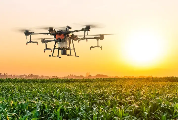
Agricultural drones come in many shapes and sizes, from large fixed-wing drones that cover hundreds of acres in one flight to quadcopters that can hover and carefully inspect a small area. The most common agricultural drones have the following features:
- Lightweight airframe made of carbon fiber or plastic
- 4, 6, or 8 rotors for vertical takeoff and landing
- Swappable sensors like visual, multispectral, hyperspectral, and thermal cameras
- GPS for mapping and waypoint-based autonomous flight
- LiDAR sensors for accurate 3D terrain mapping
- Extended flight time (15-45 minutes per battery)
- Automated flight and mapping software
When paired with specialized software, these ag drones can autonomously survey fields, create detailed crop health maps, and allow farmers to precisely monitor their crops throughout the growing season.
Benefits of Agricultural Drones
Agricultural drones provide numerous benefits to farmers, including:
Efficient Crop Monitoring and Surveying
One of the biggest advantages of ag drones is their ability to quickly survey large areas of land. Using a drone, a farmer can fly over their entire farm in less than an hour and take images of their crops. This allows them to identify any problem areas that need attention, like irrigation issues, pest infestations, or nutrient deficiencies. Drones equipped with multispectral or thermal sensors can detect crop stress weeks earlier than the naked eye. Farmers use these crop health maps to address issues quickly, before they impact the whole field.
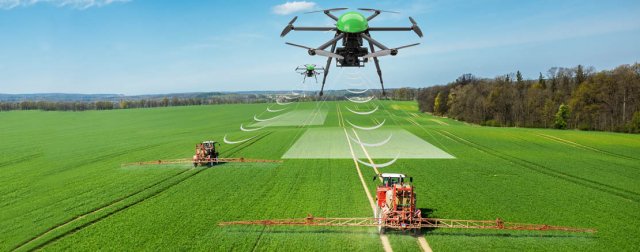
Precise Chemical Application
Some agricultural drones can carry and spray liquid pesticides, fertilizers, or even seeds over crops. This targeted application saves farmers time and money compared to broad spraying. Drones also increase spraying accuracy and reduce chemical drift.
Livestock Monitoring
Farmers use drones fitted with thermal cameras to locate and monitor their livestock in vast grazing fields. The aerial view allows them to spot injured, lost or isolated animals that need attention. Drones can also help herd animals safely and efficiently.
Irrigation Management
Special multispectral cameras on drones detect moisture levels in soil and crops. Using these crop water stress maps, farmers can plan their irrigation more efficiently and avoid over or under watering different parts of their fields.
3D Field Mapping
Agricultural drones equipped with LiDAR sensors can map a field in 3D with accuracy down to 2-3 inches. This data helps farmers estimate the volume of biomass and grain in their fields so they know the exact expected harvest totals.
Reduced Labor Costs
Agricultural drones automate time-consuming and labor-intensive tasks like scouting fields, spraying crops, herding animals, and mapping fields. Farmers can manage more land with less labor using drones.
Increased Yields
By identifying crop issues early and strategically applying chemicals only where needed, drones help maximize crop health and yields. Studies show drone monitoring can boost crop yields by up to 10-20%.
Types of Agricultural Drones
There are many types of drones designed for different agricultural applications. The most common agricultural drone types include:
Multi-Rotor Drones
Multi-rotor drones with 4, 6 or 8 rotors are the most popular ag drones due to their ease of flight, vertical takeoff and landing, and ability to hover in place. Quadcopters (4 rotors) are the most maneuverable while hexacopters (6 rotors) and octocopters (8 rotors) can lift heavier payloads. Popular models include the DJI Mavic and Phantom series and the Sentera Double 4K.
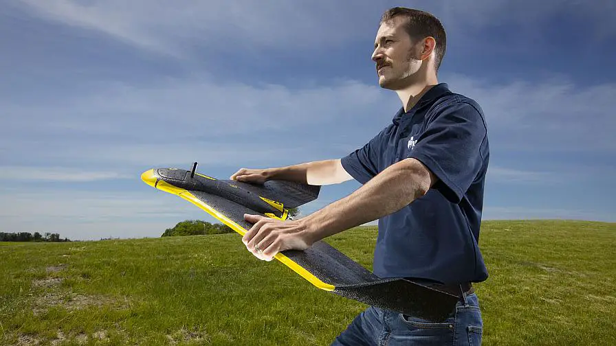
Fixed-Wing Drones
Fixed-wing ag drones typically have longer flight times of 45 minutes or more per battery since they stay in continuous forward motion without having to hover. This makes them ideal for surveying and mapping hundreds of acres rapidly in one flight. But they require more space for takeoff and landing. Examples include senseFly eBee and PrecisionHawk Lancaster.
Hybrid VTOL Drones
These combine the versatility of quadcopters with the extended flight time of fixed-wing drones. Hybrid VTOL (vertical takeoff and landing) drones take off vertically but can transition to forward flight once at altitude. Flight times reach up to 60 minutes. Popular hybrid drones include the DJI M600 Pro and FreeFly Alta 8.
Nano Drones
Tiny drones that weigh less than 1.5 pounds and fit in your hand, like the DJI Mavic Mini. Farmers use nano drones to survey individual plants and trees up close. Their small size makes them very portable. However, their flight time is more limited at under 30 minutes.
Sensors & Cameras for Agricultural Drones
The sensors and cameras equipped on agricultural drones allow them to gather useful data about crops, soil, and livestock. Here are some of the most common types of drone sensors:
Visual Cameras
All ag drones have built-in visual cameras for capturing high-resolution (typically 12MP or more) photos and video in full color. These are useful for identifying irrigation issues, crop lodging, and pest infestations. Popular options include the Sentera Double 4K (two visual cameras) and MicaSense RedEdge cameras.
Multispectral Sensors
Multispectral sensors measure reflective light from crops at specific bandwidths across the electromagnetic spectrum. This allows farmers to detect subtle changes in plant health before visual symptoms appear. It also helps determine the nutrient status of plants. Examples include sensors from MicaSense and Slantrange.
Hyperspectral Sensors
Hyperspectral sensors capture hundreds of narrow spectral bands to produce detailed signatures of what’s happening within crops and soil. This provides in-depth data for detecting plant stress, pest damage, and nutrient levels over time. Examples include sensors from Headwall and Resonon.
Thermal Cameras
Thermal cameras detect heat emitted from crops, livestock, and objects, measured in degrees Celsius or Fahrenheit. Thermal imaging helps identify irrigation issues, count livestock, and even detect ripeness. Popular models include the FLIR Vue Pro, DJI Zenmuse XT2, and MAPIR Survey3W camera.
LiDAR Sensors
LiDAR (Light Detection and Ranging) sensors emit pulsed laser light to precisely measure distance and create detailed 3D maps of terrain, vegetation structure, and buildings. LiDAR improves navigation and field volume calculation. TopoDrone, Routescene, and Phoenix LiDAR are popular LiDAR sensors for drones.
Key Agricultural Drone Features
When selecting an agriculture drone, there are certain features that are particularly important:
Rugged, Waterproof Build
Ag drones must withstand dust, dirt, mud and exposure to water when operating in fields and around livestock. Durable plastics and high-quality components are essential.
Swappable Payloads
The ability to swap sensors as needed allows farmers to equip the drone with the most useful sensors for different applications. Easy payload integration expands the drone’s capabilities over time.
Simple Controls
Controls should be intuitive enough for new drone users to quickly learn. Autonomous flight modes and mapping software also simplify operation so farmers can focus on gathering and analyzing data.
Safety Features
Ag drones should have “return to home” functions, collision avoidance, and parachutes or other safety features in case of disrupted connection or low battery to prevent flyaways and crashes.
Modular Design
Modular components make repairs and upgrades easier over the drone’s lifetime. Interchangeable batteries, gimbal payloads, and other parts increase the drone’s reusability.
Software Ecosystem
The drone manufacturer’s software ecosystem for planning flights, processing data, and analyzing maps and 3D models is as important as the drone’s hardware. It should integrate with common precision agriculture software.
Drone Software for Agriculture
Specialized software extracts valuable insights from the data gathered by agricultural drones. Some main types include:
Photogrammetry Software
Photogrammetry software, like Pix4D Fields, DroneDeploy, and PrecisionMapper, stitches together aerial images collected by drones to create:
- Orthomosaic maps
- 3D models
- Digital elevation models.
These are all very useful for analyzing crop health patterns and topographic features.
Prescision Agriculture Suites
Many companies offer specialized precision agriculture software suites designed to process and analyze multispectral, hyperspectral, thermal and LiDAR data from drones. These include:
- AgEagle: FarmLens
- senseFly: eMotion Ag
- Sentera: FieldAgent
- Slantrange: SlantView
- Maps Made Easy
The suites allow farmers to create variable rate application maps, monitor crop stress and yield prediction, and integrate drone data with GPS enabled farm equipment.
Cloud platforms
Agricultural drone manufacturers often provide cloud-based platforms to store, process and share drone maps and data across devices. Examples include:
- DJI Terra senseFly
- SenseFly Data Management
- PrecisionHawk DataMapper
These help farmers manage, analyze and share insights over time.
Field scouting apps
Scouting apps for mobile devices help farmers inspect fields and tag insights to problem areas on drone-generated maps. Some examples include:
- Measure Ground Control
- AgronomicAI
- FarmSolutions MainSail
Apps like these improve scouting efficiency and integrate it with aerial data.
Agricultural Drone Regulations
There are federal regulations on operating and registering drones for commercial use. Here are some key requirements for agricultural drone pilots in the US:
Part 107 Remote Pilot Certificate
Anyone operating drones commercially must pass the FAA’s Part 107 exam to earn a remote pilot certificate. The certification focuses on safety standards, airspace restrictions, and aviation regulations.
Drone Registration
Commercial drones weighing over 0.55 lbs must be registered with the FAA and their unique FAA registration number marked on the outside of the drone. Registration costs $5 per drone and must be renewed every 3 years.
Getting FAA Waivers
Part 107 rules prohibit flying drones over people, at night, above 400 feet, and beyond visual line of sight without FAA waivers. Farmers must apply for waivers justifying their need to operate outside these restrictions for things like crop spraying.
Respecting Privacy
Farmers must avoid flying drones over neighboring properties without permission and securely manage sensitive aerial data to respect privacy. It’s smart to communicate with neighbors before surveying fields that border their land.
Following Local Laws
States and local jurisdictions may require additional drone registrations, training, or operational limitations beyond FAA rules. For example, pesticide application regulations may apply to crop spraying drones. Staying up-to-date on drone regulations ensures agricultural operators maintain compliance and fly safely and ethically.
Getting Started with Agricultural Drones
Here are some tips for farmers looking to incorporate drones into their operations:
Start Small
Buy an inexpensive drone for learning before investing in an expensive specialized agriculture drone. The DJI Mavic Mini and Mini 2 are great starter models priced under $500.
Gain Piloting Experience
Practice flying and controlling your drone in your backyard or open fields. Look into drone simulators like DJI’s to get experience before your FAA Part 107 exam.
Earn Your Remote Pilot Certificate
Study for and pass the FAA’s Part 107 remote pilot exam. This covers the regulations and knowledge needed to legally operate drones for agriculture commercially in the US.
Register Your Drone
Register your drone online with the FAA if it weighs over 0.55 lbs. Mark the registration number visibly on your drone before flying it commercially.
Start with Plant Health Inspections
Using a visual camera drone, inspect your fields for irrigation issues, pests and nutrient deficiencies to see firsthand how drones can enhance monitoring.
Consider Data Privacy
Take steps to manage and protect aerial data responsibly. Get permission before surveying neighbors’ properties and consider insurance to cover drone privacy risks.
Analyze to Inform Farm Decisions
Use drone maps and data to make timely management decisions on irrigation, spraying, fertilizer applications. Connect insights to operations.
Keep Improving
Continue learning about drones and accessories to enhance your farming techniques. Take advanced training courses to keep improving your aerial data collection and analysis skills.
Frequently Asked Questions
How much does an agricultural drone cost?
Agricultural drone prices range widely from about $500 for a basic consumer quadcopter used for scouting up to $30,000 for large fixed-wing mapping drones or full software and data analysis packages. More typical all-in agriculture solutions cost $5,000-$15,000.
What sensors can you put on a drone?
Some of the most common sensors for agricultural drones include visual cameras, multispectral and hyperspectral imaging sensors, thermal cameras, and LiDAR 3D mapping systems. Drones may also utilize NDVI cameras, soil moisture sensors, laser methal detectors, and more.
How will drones help farmers in the future?
Drones will help farmers survey more land faster, apply chemicals more efficiently, monitor livestock, conserve water and nutrients, and boost yields. Drones integrated with artificial intelligence and automated farm equipment will allow highly optimized, data-driven precision agriculture.
What can drones do for crops?
Drones can monitor crop health across fields, detect irrigation issues, disease and pests early, create variable rate treatment maps, spray fertilizer/pesticides directly onto crops, track growth and yields, and help determine optimal harvest times.
Do agricultural drones require a license?
In the US, commercial agricultural drone pilots must obtain an FAA Part 107 Remote Pilot Certificate by passing an aeronautical knowledge exam. No other pilot’s license is needed. Some states may require agricultural drone operator permits for pesticide spraying.
Can agricultural drones spray liquid chemicals?
Yes, some larger drones can carry tanks and spray nozzles to directly apply liquid pesticides, fertilizers, or herbicides onto crops. This requires extensive testing and certification to ensure safety and proper application. Fixed-wing unmanned crop dusters cover much more acreage than quadcopters.
What software do ag drones use?
Major drone makers like DJI, senseFly, and Sentera offer integrated ag-specific software to plan flights, process imagery into maps and models, and analyze data. There is also photogrammetry, analytics, and field scouting software from specialty developers to extract agricultural insights.
How are drones used in livestock farming?
Drones help monitor grazing cattle and other livestock using aerial photography and thermal imaging. Drone surveillance improves health monitoring, simplifies hearding with sound signals, and helps locate lost animals over large ranges. Drones also enable safer and less stressful transportation.
Do you need permission to fly a drone over private property?
Yes, in the US drone pilots need consent to fly over private property below 200 feet. Farmers should communicate with neighbors before surveying fields bordering their land to respect privacy and avoid disputes.